_PH_Banner_(Desktop)(1200x180px).png)
.jpeg)
.jpg)
During the old times, the rich and affluent would ride in helicopters to survey land prospects from their prestigious heights.

.jpg)
The poor can only imagine the shape and contour of the land through illustrated maps and take for granted that the information is true.
Now, the advent of technology is closing this gap between the rich and the poor. Drones can be employed as surveillance agents and they sure don’t cost as much as a helicopter. But why go for cheap when it could be free?
Here is a simple application of Google Maps that you can use to survey and quantify a land area. Check it out:
1/ Key in the name of the area you are interested to measure into the google maps search function
2/ Click on menu at the top left corner
3/ Convert “map” into “satellite”
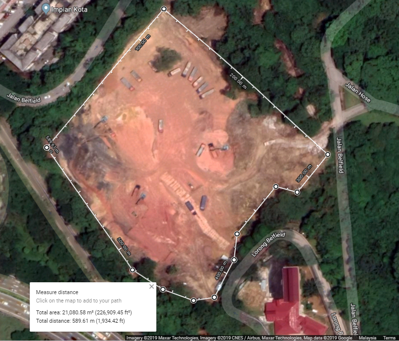
4/ Now let us attempt to measure the area of the patch of land to the east.
5/ Right click on a corner of the land area and click “Measure distance.”
6/ Left click to another corner of the land area. Note that a white measuring line has manifested and it now straddles the two points that you have created.
7/ Follow the corners of the plot of land and connect the dots until it has surrounded the entire piece.
8/ Google maps has automatically calculated the total area of the land. In this lesson, the total area is approximately 226,909.45 sq ft.
Congratulations, you can now measure the length of residential, commercial and industrial area from the comfort of your couch. But do note that Google Maps might not be time sensitive. In other words, the map in question may not be updated to reflect real time. Happy measuring.


.jpg)
.jpg)
.png)
.jpg "Sidebox")
.jpeg "Sidebox")